By Amy Katz, Conservation Director
As we often emphasize, the Transboundary Rocky Mountains are the most biologically significant habitat left for large mammals in North America (Fig. 1-2). But while the significance of this geography is clear, there is a need for an intentional, strategic approach to conservation of these lands to ensure the greatest benefit to long-term, sustainable habitat protection and wildlife connectivity. Keep It Connected addresses this need.
As the program has evolved over time, our team has created and refined a robust prioritization and decision making framework for evaluating the wildlife connectivity value of conservation projects across this landscape. This framework helps us provide funders with strategic insight into how and where to direct resources to support projects that will have the most significant impact. In this edition of From The Map Files, I want to lay out the scientific strategy behind Keep It Connected and highlight the intentionality behind the program’s project selection and curation processes.
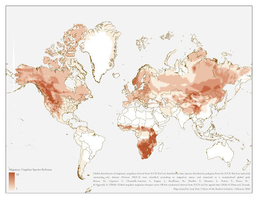
Figure 1. Global distribution of migratory ungulates derived from The International Union for Conservation of Nature data. The species diversity in the Transboundary Rocky Mountains is comparable only to southern Africa and central Asia.
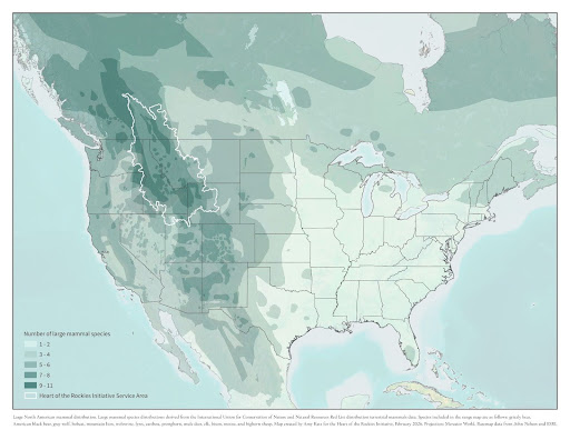
Figure 2. In North America specifically, the Transboundary Rocky Mountains contain more large carnivores and ungulates than anywhere else on the continent. This map shows the overlap with moose, wolverine, mule deer, wolf, mountain lion, grizzly bear, black bear, bobcat, lynx, caribou, bison, pronghorn, elk, and bighorn sheep. Data from the International Union for Conservation of Nature.
Our Keep It Connected team, representing a diverse background of professional experience, spanning wildlife biology, including aerial survey and population monitoring experience, private land conservation, social science, and GIS and cartography, ensures each Keep It Connected project has sufficient wildlife connectivity value to fit into the portfolio.
We build and maintain relationships with state and provincial wildlife agencies, Tribes, and university biologists, who create and hold the keys to recent telemetry data and associated movement models. Our long history collaborating with these partners allows us to access many datasets that our land trusts are unable to. We use the data to both evaluate new projects and showcase them to funders, overlaying spatial layers with land ownership and proposed conservation easement and fee title projects from our land trusts to create accessible maps that identify which projects are most critical to wildlife connectivity and fit the diverse geographic, cultural, financial, and biological priorities of our funders (Fig. 3). Specifically, we evaluate new land trust projects based on several quantitative and qualitative metrics summarized below, many of which continue to evolve over time as we respond to the needs of our land trust members and funding partners.
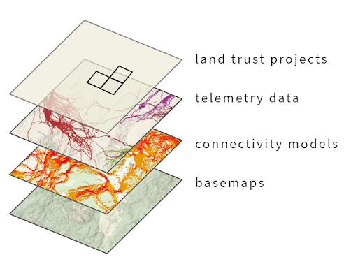
Figure 3. The Keep It Connected team utilizes many different types of data to assess each project and creates custom maps for each project to showcase the wildlife connectivity value.
Connectivity and biodiversity: Keep It Connected utilizes the best available wildlife habitat and movement data to assess projects. These data include telemetry from flight counts and short and long-term research studies, movement and connectivity models such as resource selection functions and Brownian bridge movement models, and estimated habitat ranges.
Ecosystem resilience: We consider topography, such as slope, aspect, cover, and elevation, as well as whether the property contains native vegetation and whether it is being grazed or farmed. These physical metrics can determine likelihood and suitability of carnivore and ungulate habitat, movement, and winter range. We also assess a project’s future habitat viability under a variety of conditions, thus assuring durability of permanent conservation investments in the face of long-term change. Additionally, larger properties and those with more diverse ecosystems can substantially contribute to climate resilience: this often factors into our decision-making, though small properties can be incredibly important for wildlife movement in specific pinch points or corridors.
Conservation context and community benefit: Keep It Connected operates across a much larger region than that of our land trust partners, allowing us to think strategically about private land conservation on a large landscape scale. When we curate new projects, we consider how the property fits into existing conservation work in the community and region and how it might complement local and regional connectivity and permeability. We consider whether it connects existing public or private conservation lands or whether it might serve as an anchor project for future conservation effort in a high-value area. Additionally, we assess potential community benefits of the project, such as sustaining working agricultural operations or providing public access.
Threat of conversion: Private lands are under significant threat of conversion due to increased residential and commercial development, impacts from extractive industries, expanding transportation infrastructure, and impacts of climate change: between 2015 and 2020, the Heart of the Rockies region lost an average of 100 acres of private land a day (Figure derived from Commission for Environmental Cooperation’s North American Change Monitoring System data here). Keep It Connected works to accelerate the pace at which our land trust members complete durable, collaborative conservation, attempting to keep pace with the influx of people to the region and related land use conversion that accompanies that influx. We consider whether the project is currently listed on the market, is already subdivided, or is in an area experiencing significant growth, lending itself to a more demanding, urgent funding need.
Land trust, Tribes, and landowner knowledge: Though science and data is incredibly important to our decision-making process, we also lean heavily on our land trust members and their landowner partners who are intimately familiar with these places. Oftentimes, people have game camera footage, incredible wildlife stories, and generational knowledge that can never be gleaned by a map or a model. We also value and incorporate local Indigenous wildlife history and knowledge as it relates to a potential project.
In addition to our project approval and funder curation processes, we are developing several resources for land trusts and funders to assist in strategic conservation decisions. Our public-facing data viewer allows land trusts to assess potential projects against publicly available data we use, such as generalized connectivity and grizzly bear connectivity. In partnership with the University of Wyoming, we are also creating a Montana-wide grassland prioritization tool that will assist in driving strategic dollars to the most ecologically significant, high-risk private grassland conservation projects. These resources further encourage collaboration and scientifically-backed conservation across the Transboundary Rocky Mountains, ensuring “random acts of conservation” are a thing of the past.
Featured photo by Kara Maplethorpe